


 Back
randonnee
Back
randonnee
Vers la bergerie de Dormillouse

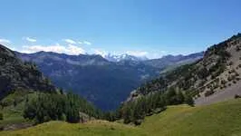
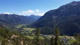
Far from the busy paths of the upper valley, the Dormillouse mountain pasture is still untamed. Its alpine meadows have enchanted many.
Description
Take the path opposite the parking lot, which rises up through the forest and is indicated by a yellow "Col de Dormillouse" sign.
The path winds up a series of switchbacks on a slightly steep ascent, continuing until you take the balcony on the left towards La Lauze.
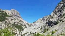
At the fork in the larch forest, take the left-hand path through a combe (La Lauze).
At another fork, take the path through the scree (arrow: Col de Dormillouse) and climb up to the mountain pasture. Once you've reached the Pinatelle ravine, continue as far as La Bergerie: the vast valley opens up to you.
If you prefer, you can continue up to the Col de Dormillouse, in which case the climb is 1100 m and takes 3h30.
The more adventurous can continue towards the Col de la Lauze, which gives access to Montgenèvre, or cross the pass to descend to the Chalets des Acles and Plampinet.
Environments
-
 Presence of livestock and guard dogs
Itinerary
-
 Distance
13.3km
Distance
13.3km
-
 Type d'itinéraire
Aller/retour
Type d'itinéraire
Aller/retour
-
 Dénivelé positif
1130m
Dénivelé positif
1130m
-
 Downhill elevation
1130m
Downhill elevation
1130m
-
 Daily duration
06:00
Daily duration
06:00
-
 Altitude maximum
2442m
Altitude maximum
2442m
Accessible tourism
-
Not accessible in a wheelchair
Location
Animals
Pets allowed: Yes


-
Distance
13.3km
-
Daily duration
06:00
-
Dénivelé positif
1130m
-
Downhill elevation
1130m