


 Back
randonnee
Back
randonnee
From Névache to Plampinet

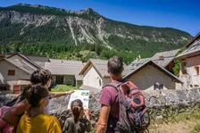
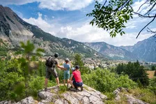
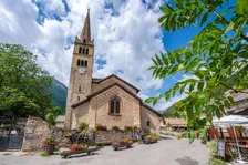

Discover the banks of the Clarée as you stroll from hamlet to hamlet from Névache.
Description
From the Forville bridge in Névache, cross the bridge and go straight ahead on the GR5C-GR57, then leave it at the Lac de Cristol junction and continue straight ahead on the forest track. Once you've reached the flat, at the level of the Longet ravine, take the track marked "sentiers des coupes". Follow this to the "chargeoir" (log dump), where the trail descends to Plampinet. For the return journey, take the same path as far as "Tabucet" and continue straight ahead on the Arras track as far as the Armands bridge. After the bridge, turn left and, before the main road, fork left again (the bridge crosses the torrent des Thures). The path leads to the municipal campsite, cross it and continue straight on to the Soupirs bridge, cross it and turn right along the Clarée to return to your starting point.
Prices
Free of charge.
Itinerary
-
 Distance
9.4km
Distance
9.4km
-
 Type d'itinéraire
Aller/retour
Type d'itinéraire
Aller/retour
-
 Dénivelé positif
110m
Dénivelé positif
110m
-
 Daily duration
03:30
Daily duration
03:30
-
 Marked trail
Yes
Marked trail
Yes
-
 Nature of the terrain
Rock,
Stone,
Ground,
Not suitable for strollers
Nature of the terrain
Rock,
Stone,
Ground,
Not suitable for strollers
Opening hours
From 15/04 to 15/11 daily.
Subject to favorable snow and weather conditions.
Ouverture complémentaire
-
Subject to favorable weather
-
Subject to snow conditions
Languages spoken
-
 English
Location


-
Distance
9.4km
-
Daily duration
03:30
-
Dénivelé positif
110m
-
Type d'itinéraire
Aller/retour