


 Retour
randonnee
Retour
randonnee
The Prorel summit

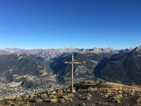
The Prorel summit overlooks Puy Saint Pierre and Briançon. On arrival, there's a superb panoramic view of the Serre Chevalier valley, the Ecrins and the Rochebrune peak.
Description
Detailed itinerary :
From the church square in Puy-Saint-Pierre, take the small tarmac road opposite the church, which climbs two hairpin bends to reach the Pralong farm.
A few metres past the farm, take the wide track. After about 100 m, take the footpath rising to the left, signposted "Notre-Dame des Neiges et ses oratoires". The narrow path leads to a track: on the right, you can see the Prorel ski lifts. Ignore the right-hand track and follow it to the left for around 100 m.
On the right, pick up the narrow path leading to the first oratory: Sainte Marie (alt: 1700m). At this first oratory, continue straight ahead to cross the track a second time and reach the Etoile du Matin oratory (alt: 1840m).
Follow the path to the left to reach the Serre Pelat ski lift, which the path passes under once. Ignore the left-hand path in the direction of the combes, and pass under the ski lift again, near the Saint-Joseph oratory (Alt: 1950). The path then continues to pass a 4th oratory-fountain of Notre-Dame de Bon Rencontre, then bends to the left to pass under the ski lift one last time.
Once you've left the ski lift, the path crosses a flat area (damp in places) to pass the 5th oratory, Saint Hubert. The route ends up winding up a steep slope in scree until it reaches the chapel on a ledge.
At the chapel, take the path just behind. It crosses the wide ski slopes to the end of the ski lifts, then winds its way up to the summit.
Return by the same route to the oratory-fountain of Notre-Dame de Bon Rencontre. Once there, take the left-hand path, which gradually descends to join the Prorel trail that leads to Ferme de Pralong, before returning to the church.
Complément accueil
During the summer season, this hike can be done from the Prorel Télécabine arrival station (3km return - 190m ascent).
Environnements
-
 Mountain view
-
Mountain location
-
Village -2 km away
-
Panoramic view
Tarifs
Free access.
Itinéraire
-
 Distance
12km
Distance
12km
-
 Type d'itinéraire
Aller/retour
Type d'itinéraire
Aller/retour
-
 Dénivelé positif
1009m
Dénivelé positif
1009m
-
 Dénivelé négatif
1014m
Dénivelé négatif
1014m
-
 Durée journalière
06h30
Durée journalière
06h30
-
 Itinéraire balisé
Oui
Itinéraire balisé
Oui
-
 Précision balisage
Yellow signs and markings.
Précision balisage
Yellow signs and markings.
-
 Nature du terrain
Stone,
Ground,
Not suitable for strollers
Nature du terrain
Stone,
Ground,
Not suitable for strollers
-
 Altitude maximum
2278m
Altitude maximum
2278m
Période d'ouverture
From 15/05 to 15/10 daily.
Subject to favorable snow and weather conditions.
Ouverture complémentaire
-
Subject to favorable weather
-
Subject to snow conditions
Langues parlées
-
 French
Localisation


-
Distance
12km
-
Durée journalière
06h30
-
Dénivelé positif
1009m
-
Dénivelé négatif
1014m