


 Retour
randonnee
Retour
randonnee
The Mélézin on snowshoes

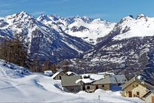
In the heart of a vast forest of snow-covered larches, this snowshoe hike will take you up to discover the hamlet of Mélézin perched at an altitude of 1880 metres. The reward is a unique view of the Durance and Guisane rivers.
Description
By car, park at the Centre Montagne parking lot, at the start of the cross-country ski trails. In winter, the Ayes road is snow-covered and closed to traffic.
From the parking lot, retrace your steps onto the Route des Ayes and put on your snowshoes.
The wide Ayes trail rises to reach the forest. Follow this track to the "Ayes/Melezin" fork.
Take the left-hand track towards Les Ayes. Caution: the right-hand track leads to Mélézin via the summer road, and is much longer (8 km one way).
A little further on - approx. 200 m - take the snow-covered path on the right, marked with a yellow "Le Mélézin" sign.
This relatively well-marked route is easily distinguished in the snow between the larch trees and climbs steeply upwards in the heart of the Bois du Villard .
Soon on the right, a small path leads to the Clairière du Lauzin (a short detour is possible to see the Clairière and then return to the main itinerary).
After passing Le Lauzin, ignore the track on the right and take the one on the left until you reach a wide forest track. Cross it to get back to the itinerary opposite.
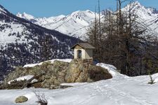
The climb then becomes a little steeper until you come to a rocky spur (the Oratoire Saint-Augustin is not visible at this time of year, as it is buried under the snow), with the Mélézin chalets in the background.
The return journey takes the same route.
Complément accueil
In winter, the Ayes road is snow-covered and closed to traffic.
Progress on snow-covered terrain is far more demanding than in summer. It requires special equipment and knowledge of mountain risks.
An ungroomed route may require you to "make tracks", and requires good physical condition and preparation.
- Consult the weather forecast
- Avalanche risk assessment bulletin
- Consult guide recommendations
- Make sure you have the right equipment, including avalanche transceivers, shovels and probes.
- Choose an itinerary suited to your physical condition
- Never set off alone.
Environnements
-
 Forest location
-
Mountain view
-
Mountain location
-
Panoramic view
Tarifs
Free access.
Itinéraire
-
 Distance
7km
Distance
7km
-
 Type d'itinéraire
Aller/retour
Type d'itinéraire
Aller/retour
-
 Dénivelé positif
586m
Dénivelé positif
586m
-
 Durée journalière
05h00
Durée journalière
05h00
-
 Itinéraire balisé
Oui
Itinéraire balisé
Oui
-
 Précision balisage
Yellow signs.
Précision balisage
Yellow signs.
-
 Nature du terrain
Non-groomed itinerary
Nature du terrain
Non-groomed itinerary
-
 Altitude maximum
1880m
Altitude maximum
1880m
Période d'ouverture
From 01/12 to 30/04 daily.
Subject to favorable snow and weather conditions.
Ouverture complémentaire
-
Subject to favorable weather
-
Subject to snow conditions
Localisation
Animaux
Animaux acceptés : Oui


-
Distance
7km
-
Durée journalière
05h00
-
Dénivelé positif
586m
-
Type d'itinéraire
Aller/retour