Top 7 lakes in La Grave
Whether for a leisurely hike or to contemplate their beauty from a mountaintop, mountain lakes invite contemplation, meditation and wonder.
Objective mountain lakes
Mountain lakes are the natural mirrors in which to observe these beautiful white ladies and the immensity of the sky. You're bound to be charmed by the tranquility of the setting, the ecosystem that revolves around these waterholes and the relaxing atmosphere they create.
Take a family outing to Lac du Pontet or Lac du Puy Vachier, cross the Emparis plateau to see La Meije through the mirror of Lac Lérié and Lac Noir, or discover the alpine flora around Lac du Goléon. The glacial Lac d'Arsine and Lac du Pavé offer a more mineral environment on the edge of the high mountains.
LAKES NOIR AND LÉRIÉ PLATEAU D'EMPARIS

Face au massif de la Meije et ses glaciers, ces deux lacs sont situés au cœur d’un vaste plateau vert et ondulant : le plateau d’Emparis… Pour un moment hors du temps.
Contemplate the waters and their many reflections.
Les plus courageux seront récompensés par un lever de soleil grandiose.
Advice from the tourist office:
Discover these lakes out of season to avoid too many people and enjoy them to the full.
Start: Hameau du Chazelet, La Grave
Duration: 5h30 AR
Ascent : 750 m
Round trip distance: 17 km
Level : medium (long)
Maps: IGN Top 25 3435 ET Valloire or 3436 ET Meije Pelvoux
Details of the Lac Noir et Lérié trail on the Emparis plateau
THE LAKE DU GOLÉON

It's great to rest on the "ribbons", natural grass terraces delineated by the rocks.
After a siesta under the watchful eye of the Meije, we're off in search of alpine flowers or for a tour of the lake on the Natura 2000 interpretation trail.
Advice from the tourist office:
Enjoy a meal or an overnight stay at the Goléon refuge.
Start : Hières hamlet, La Grave
Height difference : 670 m
Duration : 4h AR
Level : medium
Maps : 3435 ET Valloire
THE LAKE DU PONTET

From the edge of this small, easily accessible lake, you can enjoy spectacular views of some of the most beautiful peaks in the Ecrins National Park, while basking in the sunshine of the alpine meadows.
A little extra: refreshment bar/snack bar in summer
Start : Villar d'Arène - Hameau des Cours
Duration : 2 hours
Difference in altitude: 356 m
Level : easy
Map: IGN Top 25 3435 ET Valloire
Les lacs du glacier d'arsine
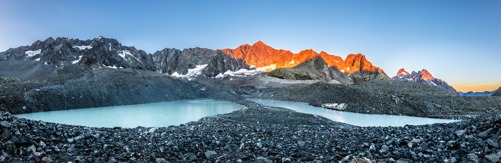
Recently created by the melting of the Glacier d'Arsine, the Lac du Glacier d'Arsine is an absolute must-see. The glacier's cliff face, which plunges directly into the lake, lends the area a typical high-mountain atmosphere, while remaining easily accessible to hikers.
Ce site au cœur du Parc national des Écrins permet de découvrir l’univers de la haute montagne, des moraines et des glaciers à travers une longue randonnée, mais sans difficulté technique.
Departure point : Col du Lautaret (panoramic aerial trail) or Arsine hamlet, Villar d'Arène
Duration : 6h AR
Difference in altitude : 450 m /800 m
Round trip distance: 19 km
Level : medium (long)
Maps: IGN Top 25 3436 ET Meije Pelvoux
Le lac du pavé
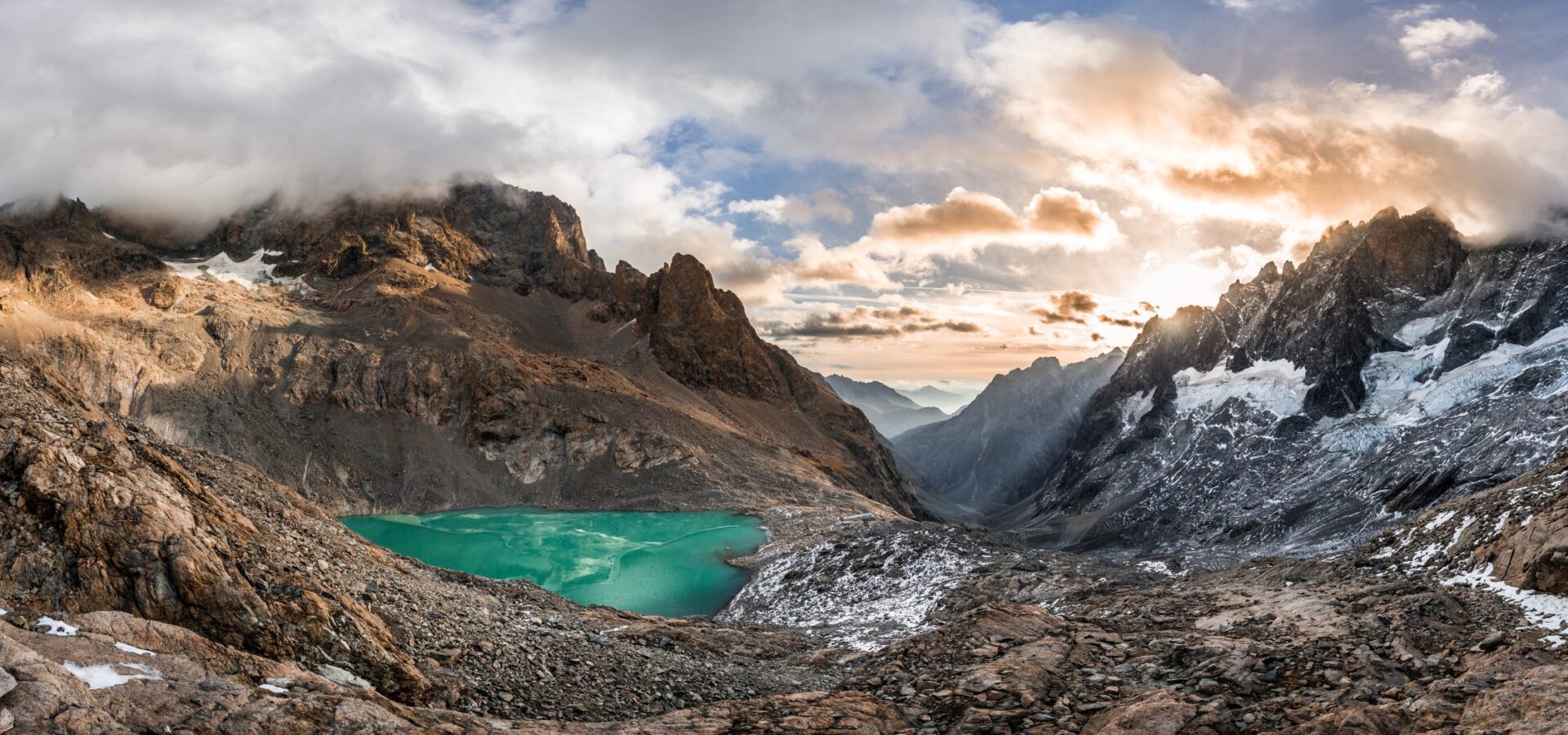
This lake has to be earned, as the ascent through moraines and rocks is long. On arrival, an emerald-colored lake contrasts magnificently with the mineral world of the high peaks. A true high-altitude lake with a touch of the Himalayas!
Advice from the tourist office:
Take a 2-day hike and spend the night at the Pavé refuge.
Start : Arsine, Villar d'Arène
Duration : 8 h
Ascent : + 1150 m
Distance : A-R: 21 km
Level : difficult
Maps: IGN Top 25 3436 ET Meije Pelvoux
LE LAC DU PUY VACHIER

Ce lac d’altitude aux eaux limpides est niché dans un creux au pied des célèbres couloirs du domaine de ski freeride La Grave La Meije. La traversée jusqu’au lac offre de très belles vues sur le plateau d’Emparis ainsi que les pics du Goléon et des Trois Évêchés.
Le refuge Chancel, perché au-dessus du lac, permet plonger les yeux dans le bleu foncé en sirotant un café.
Departure : 2400 m station, Meije glaciers cable car
Duration : 1h30
Difference in altitude : + 130 m
Distance A-R: 3.5 km
Level : easy
Maps: IGN Top 25 3436 ET Meije Pelvoux
AROUND DE LA ROMANCHE

Suivre la Romanche du hameau d’Arsine vers sa source au pied des sommets au cœur du Parc national des Écrins, c’est un festin d’eau fraîche. Vous la verrez en torrent tumultueux, en cascade, en long fleuve tranquille, en petit cours d’eau pour patauger et en petit lac limpide.
Vous pouvez aller jusqu’aux sources de la Romanche ou vous arrêter avant, au niveau du petit lac Pers ou au pont de Valfourche, où la vallée se divise en deux.
Start: Arsine, Villar d'Arène
Ascent: 480 m
Duration: 5h00
Round trip distance: 15 km
Level: medium (long if you go all the way to the springs)
Maps: 3436 ET Meije Pelvoux