


 Retour
randonnee
Retour
randonnee
The Arsine corrie via the Crevasses path
A long ascent around the Massif du Combeynot for a full day’s hike towards the lakes of the Arsine glacier corrie.
Description
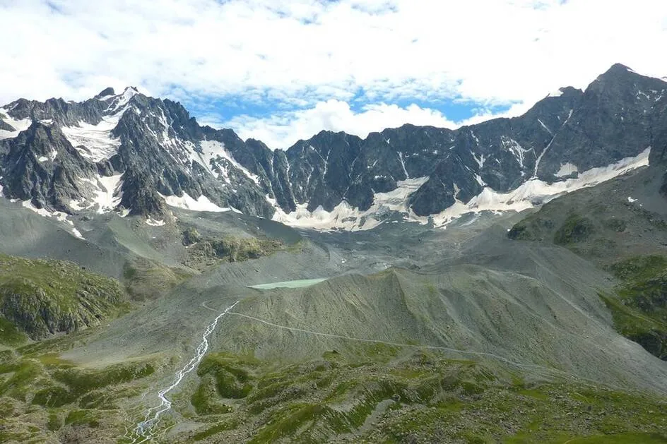
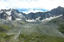
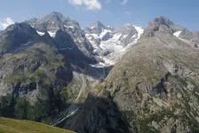
Early in the morning, the rising sun lights up the glacier outlines of the Ecrins peaks, while the sheep are resting in the immense Alpine pastures that begin near the Col du Lautaret. A day’s walk awaits us for a gradual introduction to summits where some of the finest hours of mountain climbing have taken place, in the highest range in the southern Alps. After the efforts of a long, but gradual ascent, the Arsine glacier corrie topped by majestic summits are an awe-inspiring reward (Pic des Agneaux and Pic de Neige Cordier).
Pierrick Navizet, responsible for the eco-tourism project at the National Park
Tarifs
Free access.
Bons plans
The way to the Crevasses path is across uneven schist slopes. Care needs to be taken in this slippery terrain, especially in wet weather.
Is in the midst of the park : The national park is an unrestricted natural area but subjected to regulations which must be known by all visitors.
Itinéraire
-
 Distance
21.07km
Distance
21.07km
-
 Type d'itinéraire
Aller/retour
Type d'itinéraire
Aller/retour
-
 Dénivelé positif
666m
Dénivelé positif
666m
-
 Dénivelé négatif
666m
Dénivelé négatif
666m
-
 Durée journalière
07:30
Durée journalière
07:30
-
 Altitude maximum
2459m
Altitude maximum
2459m
Localisation

Thèmes
-
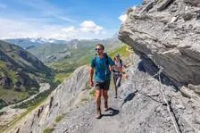
Guidebook with maps/step-by-step : From the car park below the Col du Lautaret, make your way up and you will soon arrive at a crossroads. Take the right-hand fork and leave the Laurichard path. Cross a footbridge and walk up the hillside. The path crosses several streams and areas of bushes leading to a more open space where it arrives at the Belvedere de L'Homme. Soon after, go through (and then close) a barrier before going down the sometimes uneven schist slopes of a path called Les Crevasses, with some care to be taken in wet weather on the slippery terrain. You arrive at the Villar d'Arène mountain pasture and cross the GR 54 near the weather station. Soon afterwards, leave the path leading to the refuge on the right and continue up the Rif de la Planche valley to arrive at the Col d'Arsine along the GR 54. You then leave the GR 54, and turn right to cross the large frontal moraine of the Arsine glacier. From this rise shaped by the movement of glaciers, two large lakes at the foot of a corrie mark the end of the ascent (2,455 m). Take the same route to return to the car park where the trail started. On the way back, you can opt for a variation via the Alpe de Villar d’Arène refuge.
-
Tips : The way to the Crevasses path is across uneven schist slopes. Care needs to be taken in this slippery terrain, especially in wet weather.
Is in the midst of the park : The national park is an unrestricted natural area but subjected to regulations which must be known by all visitors.


-
Distance
21.07km
-
Durée journalière
07:30
-
Dénivelé positif
666m
-
Dénivelé négatif
666m