


 Retour
equipement
Retour
equipement
From La Grave to Col de l'Échelle


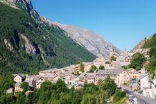
This itinerary takes you through the beautiful Clarée valley before climbing the Col de l'Echelle. At the summit, push on to the end of the plateau to enjoy the view of Italy.
Description
Detailed itinerary :
- From the parking lot, turn right towards Briançon on the RD 1091. Pass through the village of La Grave.
- As you leave La Grave, go through the Serre du Coin tunnel, then the Ardoisières tunnel (be careful, the tunnels are poorly lit). Continue on the RD 1091.
- Go around the village of Villar d'Arène and continue towards Briançon and Col de Lautaret.
- At the Col de Lautaret, follow the RD 1091 down into the Serre Chevalier valley as far as Briançon.
- Once in Briançon, after the town entrance sign, pass the medical center and take the 1st road on the left to join the route de Grenoble.
- Follow route de Grenoble up to the Champs de Mars traffic circle. At the traffic circle, take the 4th exit on the left towards Montgenèvre, to join the RN 94.
- At the Briançon exit, continue on the RN 94 to the La Vachette crossroads.
- At the crossroads, turn left towards Névache/Vallée de la Clarée. Enter the village of La Vachette and drive up the Clarée Valley to Névache (approx. 10 km).
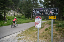
- Shortly before reaching Névache, turn right towards Col de l'Echelle and start climbing.
- At the summit, continue straight on, stopping just before the descent to Italy.
- Return to La Grave by the same route.
Équipements
-
 Public WC
-
Cycle tourism route
-
Free car park
Environnements
-
 Mountain view
Tarifs
Free access.
Itinéraire
-
 Distance
120.6km
Distance
120.6km
-
 Type d'itinéraire
Aller/retour
Type d'itinéraire
Aller/retour
-
 Dénivelé positif
2014m
Dénivelé positif
2014m
-
 Dénivelé négatif
2003m
Dénivelé négatif
2003m
-
 Durée journalière
07h30
Durée journalière
07h30
-
 Itinéraire balisé
Oui
Itinéraire balisé
Oui
-
 Nature du terrain
Hard coating (tar, cement, flooring)
Nature du terrain
Hard coating (tar, cement, flooring)
-
 Altitude moyenne
1690m
Altitude moyenne
1690m
-
 Altitude maximum
2058m
Altitude maximum
2058m
Période d'ouverture
From 01/05 to 15/11 daily.
Langues parlées
-
 French
Localisation


-
Distance
120.6km
-
Durée journalière
07h30
-
Dénivelé positif
2014m
-
Dénivelé négatif
2003m