


 Retour
randonnee
Retour
randonnee
Crossing from Lautaret to Alpe de Villar

A trail that will delight fans of wide open spaces, pastoral farming and thrills on the schist paths of Les Crevasses.
Description
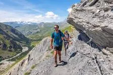
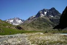
Famous for regularly featuring in the Tour de France, the Col du Lautaret is also the starting point for some of the best hiking trails. The crossing to Alpe de Villar d'Arène along the vertiginous path of Les Crevasses is a very pleasant one in dry weather. The landscapes are wide-open and impressive, and deeply marked by the high summits, by pastoral farming and agricultural terraces that were honed out of the slopes around the villages of La Grave and Villar d'Arène.
Tarifs
Free access.
Bons plans
The way to the Crevasses path is across uneven schist slopes. Care needs to be taken in this slippery terrain, especially in wet weather.
Is in the midst of the park : The national park is an unrestricted natural area but subjected to regulations which must be known by all visitors.
Itinéraire
-
 Distance
12.96km
Distance
12.96km
-
 Type d'itinéraire
Aller/retour
Type d'itinéraire
Aller/retour
-
 Dénivelé positif
279m
Dénivelé positif
279m
-
 Dénivelé négatif
279m
Dénivelé négatif
279m
-
 Durée journalière
04:30
Durée journalière
04:30
-
 Altitude maximum
2124m
Altitude maximum
2124m
Localisation

Thèmes
-
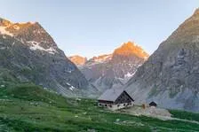
Guidebook with maps/step-by-step : From the car park below the Col du Lautaret, head upwards and you will soon arrive at a crossroads. Take the right-hand fork and leave the Laurichard path. Cross a footbridge and make your way up the hillside. The path crosses several streams and areas of bushes leading to a more open space where it arrives at the Belvedere de L'Homme. Soon after, go through (and then close) a barrier before going down the sometimes uneven schist slopes of a path called Les Crevasses, with some care to be taken in wet weather on slippery terrain. You arrive at the Villar d'Arène mountain pasture and cross the GR 54 near the weather station. Soon afterwards, leave the GR 54 and make a right before continuing straight ahead as far as the Alpe de Villar-d’Arêne refuge.
Go back the same way as far as the Col du Lautaret. -
Tips : The way to the Crevasses path is across uneven schist slopes. Care needs to be taken in this slippery terrain, especially in wet weather.
Is in the midst of the park : The national park is an unrestricted natural area but subjected to regulations which must be known by all visitors.


-
Distance
12.96km
-
Durée journalière
04:30
-
Dénivelé positif
279m
-
Dénivelé négatif
279m