


 Retour
randonnee
Retour
randonnee
6-day tour between Écrins and Clarée

An original loop linking the massifs of Les Écrins and Les Cerces, another mountain setting whose treasures are revealed with every passing step.
Description
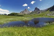
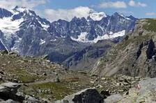
The route runs through passes once used by Briançon's farmers and miners, amid the iconic peaks towering over the area, such as the Grand Aréa and the Tête de la Cassille. The views give onto landscapes marked by herding activities above the great larch forests to the north while to the south, the massif of Les Écrins offers almost unearthly silhouettes reminiscent of the Himalayas beyond the Guisane valley. The wildlife here is symbolised by the ibex which frequents the massif in complete tranquillity, in this unspoiled landscape setting... Floral diversity abounds, from the banks of the Clarée to the rocky ground at high altitude.
Tarifs
Free access.
Bons plans
Before setting out for the refuges, enquire about their opening times.
Protect yourself from the sun in high summer, even on more shaded routes. Take sun cream.
Is in the midst of the park : The national park is an unrestricted natural area but subjected to regulations which must be known by all visitors.
Itinéraire
-
 Distance
58.59km
Distance
58.59km
-
 Type d'itinéraire
Aller simple
Type d'itinéraire
Aller simple
-
 Dénivelé positif
3108m
Dénivelé positif
3108m
-
 Dénivelé négatif
3112m
Dénivelé négatif
3112m
-
 Durée journalière
144:00
Durée journalière
144:00
-
 Itinéraire balisé
Oui
Itinéraire balisé
Oui
-
 Altitude maximum
2643m
Altitude maximum
2643m
Localisation

Thèmes
-
Tips : Before setting out for the refuges, enquire about their opening times.
Protect yourself from the sun in high summer, even on more shaded routes. Take sun cream.
Is in the midst of the park : The national park is an unrestricted natural area but subjected to regulations which must be known by all visitors. -
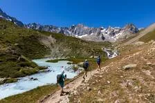
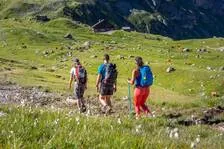
Guidebook with maps/step-by-step : From the ParK's information centre at the Col du Lautaret, take the GR®50 which drops down to the Pied du Col and the alpine pastures, and on to the refuge of L’Alpe de Villar d’Arène. From the refuge, climb the footpath up to the Col d'Arsine (2,348m) and the Arsine glacial lake. Two large lakes at the foot of a cirque mark the end of the ascent (2,455m). Retrace your steps back to the footpath, which passes small lakes and a shepherd's hut. After a stretch of rocky ground and a few zigzags, you come to the Lac de La Douche and then a larch forest. Follow the banks of the mountain stream until you come to the village of Le Casset. Head uphill towards the Vallon de La Moulette. Carry on along the GR50 and 57 to the Col de Buffère and on to the refuge. From the refuge, follow the GR downhill towards the valley and continue towards the Pont de Lacha and La Meuille along a good path. Shortly after the chalets of La Meuille, you can go and admire the Fontcouverte waterfall. The footpath then climbs up to the chalets of Laraux and then on to the refuge of Le Chardonnet. From the refuge, you reach the Lac du Châtelard via a mainly grassy footpath. It then leads on gently to the Col du Chardonnet (2,638m). The descent starts along some stony terrain. After a few steep, vertiginous stretches, the footpath winds above the valley. Follow the Torrent du Rif mountain stream and continue through an alpine pasture strewn with boulders until you come to a point looking down over the chalets of L'Alpe du Lauzet, then drop back down to Pont de l'Alpe. At the hamlet of Le Lauzet, join the GR®50 which climbs up through the valley on the left-hand bank of the Guisane. You gradually approach the pass through these alpine pastures. After a few wide, gently rising bends you come to the pass at last!


-
Distance
58.59km
-
Durée journalière
144:00
-
Dénivelé positif
3108m
-
Dénivelé négatif
3112m