


 Retour
equipement
Retour
equipement
Les Fréaux Vertical kilometer
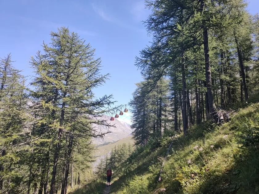
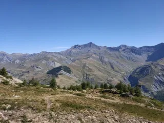


This is the Fréaux vertical kilometer: a short distance, but a steep climb. It's a breathtaking climb, and not just because of the view from the Chancel refuge, perched at an altitude of 2506 metres.
Description
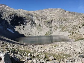
This steep and demanding route starts at Les Fréaux, at an altitude of 1370 metres. A forest trail follows the cable cars of the Téléphériques des Glaciers de La Meije. The route passes through Pierre Farabo and Côte Fine, before leading to the Puy Vachier lake. At this point, the hardest part is behind us, and the view opens out over the Buffe and Goléon valleys. If the refuge is guarded, you can enjoy a home-cooked meal and refresh yourself on the terrace.
Équipements
-
 Public WC
-
Car park
-
Defibrillator
-
Parking nearby
-
Trail route
-
Charging stations for electric vehicles
Environnements
-
 Forest location
-
Mountain location
-
Lake -5km away
-
River -5 km away
-
Waterside
Tarifs
Free access.
Itinéraire
-
 Distance
4.8km
Distance
4.8km
-
 Type d'itinéraire
Aller/retour
Type d'itinéraire
Aller/retour
-
 Dénivelé positif
1200m
Dénivelé positif
1200m
-
 Dénivelé négatif
1200m
Dénivelé négatif
1200m
-
 Durée journalière
02:00
Durée journalière
02:00
-
 Itinéraire balisé
Oui
Itinéraire balisé
Oui
-
 Nature du terrain
Rock,
Stone,
Ground
Nature du terrain
Rock,
Stone,
Ground
-
 Altitude moyenne
1700m
Altitude moyenne
1700m
-
 Altitude maximum
2506m
Altitude maximum
2506m
Période d'ouverture
From 01/05 to 30/10 daily.
Subject to favorable snow and weather conditions.
Ouverture complémentaire
-
Subject to favorable weather
-
Subject to snow conditions
Langues parlées
-
 English
-
 French
Localisation
Animaux
Animaux acceptés : Oui


-
Distance
4.8km
-
Durée journalière
02:00
-
Dénivelé positif
1200m
-
Dénivelé négatif
1200m


-
agenda La Grave
Trail de la Meije
- Competitive sport
Saturday 5 September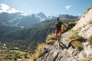
-
Villar-d'Arêne
 commerce et service Ouvert
Association - Dénivelé positif
-
La Grave
 equipement
The Aiguillon's loop
- Distance 15km
- Durée journalière 02:00
- Dénivelé positif 650m
- Dénivelé négatif 650m
-
La Grave
 equipement
The Meije Marathon
- Distance 42km
- Durée journalière 06:00
- Dénivelé positif 2070m
- Dénivelé négatif 2070m
-
La Grave
 equipement
The Meije trophy
- Distance 26km
- Durée journalière 03:30
- Dénivelé positif 1280m
- Dénivelé négatif 1280m